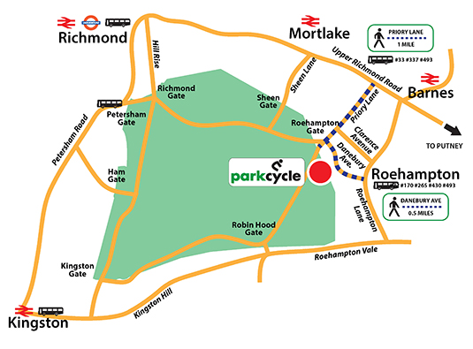
Nearest station is Barnes over ground rail station. The shortest walk is from Roehampton via Danebury Avenue.
Parkcycle is most easily accessed by car however it is possible to reach the location using public transport and a 15 minute walk - see the alternatives below!
Accessing by Car
If you are hiring on a weekend and you are coming by car, then you will need to plan your journey in order to avoid the Royal Parks traffic restrictions in the park.
You will need to arrive at Roehampton Gate using roads that are outside the park as it is not possible to travel there via the park roads from Richmond Gate or Kingston Gate at the weekend.
Full details can be found on The Royal Parks’ Movement Strategy pamphlet on the Royal Parks website.
Parking
The cycle centre is in the Roehampton Gate Car Park next to the Cafe and there is plenty of space.
There are six car parks in all within Richmond Park and these are clearly marked on the official park maps. Parking is currently free.
Occasionally when the park is busy the car parks can become full; in this situation please do not park on the roads or grassland (you will be ticketed).
Disabled and Blue Badge Access
All car parks have designated disabled spaces.
There is a disabled-badge-holders only car park for the Isabella Plantation, access via Ham Cross.A free minibus service will operate every Monday, Wednesday, and Friday, from 5 April until 29 November 2023, between the hours of 9:25am and 4:20pm.
Royal Parks Minibus (Seasonal)
It will run between all the Richmond Park car parks, Ladderstile Gate, Richmond Gate, Pembroke Lodge, and Isabella Plantation.
The service starts and finishes at the barrier in Danebury Avenue on the Roehampton Estate and goes out to Ham, Ashburnham Road (371 bus stop), Ham Gate Avenue (near to the 65 bus stop), and new for this year, out to Mortlake Station (969 stop) outside the Community Centre. Details can be found here
Travel Guide
| Origination |
By Bus
www.tfl.gov.uk |
By Train
www.southwesttrains.co.uk |
| Richmond Town Centre |
#33 #337 #493
Alight at Priory Lane
Walk south on Priory Lane to Roehampton Gate (1.0 miles)
|
SW Train to Barnes
Walk south to Upper Richmond Road
Turn right and left onto Priory Lane
Walk south on Priory Lane to Roehampton Gate (1.4 miles)
To shorten the walk take bus #33 from Barnes Station to Priory Lane
Walk south on Priory Lane to Roehampton Gate (1.0 miles) |
| Hammersmith |
#220
Hammersmith Broadway to Putney Bridge Station; then
#265 to Rosslyn Park Rugby Clubl then
Walk south on Priory Lane to Roehampton Gate (1.0 miles) |
|
| Putney |
#430
Putney Station or Putney Bridge to Danebury Avenue
Walk along Danebury Avenue to Roehampton Gate (0.5 miles)
#265
Putney Bridge Station or Putney Pier to Rosslyn Park Rugby Club; then
Walk south on Priory Lane to Roehampton Gate (1.0 miles)
#337
Putney Station to Priory Lane
Walk south on Priory Lane to Roehampton Gate (1.0 miles) |
|
| Wimbledon |
#493
Alight at Priory Lane
Walk south on Priory Lane to Roehampton Gate (1.0 miles) |
|
| Clapham Junction |
#170
Alight at Danebury Avenue last stop
Walk north west 0.5 mile to Roehampton Gate
#337
Alight at Priory Lane
Walk south on Priory Lane to Roehampton Gate (1.0 miles) |
SW Train to Barnes
Walk south to Upper Richmond Road
Turn right and left onto Priory Lane
Walk south on Priory Lane to Roehampton Gate (1.4 miles)
To shorten the walk take bus #33 from Barnes Station to Priory Lane
Walk south on Priory Lane to Roehampton Gate (1.0 miles) |
| Waterloo & All Stations on the Brentford Loop |
|
SW Train to Barnes
Walk south to Upper Richmond Road
Turn right and left onto Priory Lane
Walk south on Priory Lane to Roehampton Gate (1.4 miles)
To shorten the walk take bus #33 from Barnes Station to Priory Lane
Walk south on Priory Lane to Roehampton Gate (1.0 miles) |